Earth Science Week Classroom Activities
A Model of Three Faults

Activity Source:
Adapted from USGS
Background
One of the most frightening and destructive phenomena of nature is a severe earthquake and its terrible aftereffects. An earthquake is a sudden movement of the Earth, caused by the abrupt release of strain that has accumulated over a long time. For hundreds of millions of years, the forces of plate tectonics have shaped the Earth as the huge plates that form the Earth’s surface slowly move over, under and past each other. Sometimes the movement is gradual. At other times, the plates are locked together, unable to release the accumulating energy. When the accumulated energy grows strong enough, the plates break free. If the earthquake occurs in a populated area, it may cause many deaths and injuries and extensive property damage.
Today we are challenging the assumption that earthquakes must present an uncontrollable and unforecastable hazard to life and property. Scientists have begun to estimate the locations and likelihoods of future damaging earthquakes. Sites of greatest hazard are being identified, and designing structures that will withstand the effects of earthquakes.
Materials
Objective
Students will observe fault movements on a model of the earth’s surface.
Time Needed
1 or 2 Class periods
Materials Needed (per group)
- Physiographic map of the world
- Crayons or colored pencils
- Scissors
- Tape or glue
- Metric ruler
- Construction paper
- Fault Model Sheet (included)
Instructions
- Have students work in pairs or small groups.
- Display the fault models in the classroom after the activity.
- An excellent world physiographic map, showing the ocean floor, can be obtained from the National Geographic Society.
Application Phase
- Explain that faults are often (but not always) found near plate boundaries and that each type of fault is frequently associated with specific types of plate movements. However, you can probably find all types of fault movement associated with each type of plate boundary.
- Normal faults are often associated with divergent (tensional) boundaries.
- Thrust faults are often associated with convergent (compressional) boundaries.
- Strike-slip faults are often associated with transform (sliding) boundaries.
- Ask the following questions:
- What kind of faults would you expect to find in the Himalaya Mountains? Why?
- What kind of faults would you expect to find along the Mid-Atlantic Ridge? Why?
- What kind of fault is the San Andreas Fault? Is California likely to “fall off into the Pacific Ocean”? Why?
- Explain that not all faults are associated with plate boundaries. Explain that there is a broad range of faults based on type, linear extension, displacement, age, current or historical activity and location on contintental or oceanic crust. Have students research examples of non-plate boundary faults.
- Explain to students that the stresses and strains in the earth’s upper layers are induced by many causes: thermal expansion and contraction, gravitational forces, solid-earth tidal forces, specific volume changes because of mineral phase transitions, etc. Faulting is one of the various manners of mechanical adjustment or release of such stress and strain.
- Have students research and report on the types of faults found in your state.
Extension
- Have students Identify the fault movements in the recent Loma Prieta, California earthquake.
- Have students research the fault histories and recent theories concerning the Northridge, California Earthquake, the New Madrid, Missouri , and the Anchorage, Alaska fault zones.
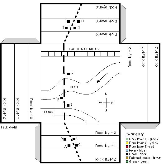
Coloring Key
- Rock Layer X - green
- Rock Layer Y - yellow
- Rock Layer Z - red
- River - blue
- Road - black
- Railroad tracks - brown
- Grass - green
Part 1
Exploration Phase
- You may wish to introduce this activity by asking students:
- Can you name a famous fault?
- What happens when giant fractures develop on the Earth and the pieces move relative to one another?
- Illustrate compressive earth movements using a large sponge by squeezing from both sides, causing uplift. Using a piece of latex rubber with a wide mark drawn on it, illustrate earth tension, by pulling the ends of the latex to show stretching and thinning.
- Have students construct a fault model using the Fault Model Sheet. Instructions to students:
- Color the fault model that is included according to the color key provided.
- Paste or glue the fault model onto a piece of construction paper.
- Cut out the fault model and fold each side down to form a box with the drawn features on top.
- Tape or glue the corners together. This box is a three dimensional model of the top layers of the Earth’s crust.
- The dashed lines on your model represent a fault. Carefully cut along the dashed lines. You will end up with two pieces. You may wish to have your students tape or glue a piece of construction paper on the side of the two fault blocks along the fault face. This will help with the demonstration.
Note that an enlarged version of the fault block model can be made for classroom demonstrations.
- Have students develop a model of a normal fault.
- Instructions to students: Locate points A and B on your model. Move point B so that it is next to Point A. Observe your model from the side (its cross-section). Have students draw the normal fault as represented by the model they have just constructed.
Concept Development
- Ask the following questions:
- Which way did point B move relative to point A?
- What happened to rock layers X, Y and Z?
- Are the rock layers still continuous?
- What likely happened to the river? the road? the railroad tracks?
- Is this type of fault caused by tension, compression or shearing?
- Explain that this type of fault is known as a normal fault.
- Have students label their drawing “normal fault”.
- Many normal faults are found in Nevada. This is because Nevada is located in a region called the Basin and Range Province where the lithosphere is stretching.
Part 2
Exploration Phase
Have students develop a model of a thrust fault. Instructions to students:
Locate points C and D on your model. Move Point C next to point D. Observe the cross-section of your model.
Have students draw the thrust fault as represented by the model they have just constructed.
Concept Development
- Ask the following questions:
- Which way did point D move relative to point C?
- What happened to rock layers X, Y and Z?
- Are the rock layers still continuous?
- What likely happened to the river? the road? the railroad tracks?
- Is this type of fault caused by tension, compression or shearing?
- Explain that this type of fault is known as a thrust fault.
- Have students label their drawing “thrust fault”.
- An example of a thrust fault is the fault in which the Northridge earthquake occurred. The thrusting movement raised the mountatins in the area by as much as 70 cm.
Part 3
Exploration Phase
Have students develop a model of a strike-slip fault. Instructions to students:
Locate points F and G on your model. Move the pieces of the model so that point F is next to point G.
Have students draw an overhead view of the surface as it looks after movement along the fault.
Concept Development
- Ask the following questions:
- If you were standing at point F and looking across the fault, which way did the block on the opposite side move?
- What happened to rock layers X, Y, and Z?
- Are the rock layers still continuous?
- What likely happened to the river? the road? the railroad tracks?
- If the scale used in this model is 1 mm = 2 m, how many meters did the earth move when the strike-slip fault caused point F to move alongside point G? (Note that this scale would make an unlikely size for the railroad track!) If there were a sudden horizontal shift of this magnitude it would be about five times the shift that occurred in the 1906 San Andreas fault as a result of the San Francisco earthquake.
- Is this type of fault caused by tension, compression or shearing?
- Explain that this type of fault is known as a strike-slip fault.
- Have students label their drawing “strike-slip fault”.
- Explain to the students that a strike-slip fault can be described as having right or left-lateral movement. If you look directly across the fault, the direction that the opposite side moved defines whether the movement is left-lateral or right-lateral. The San Andreas fult in California is a right-lateral strike-slip fault.
Model
USGS Learning Web Lesson Plans