Earth Science Week Classroom Activities
Different Times, Different Environment
Activity Source:
Organizing partners of Geologic Map Day are the U.S. Geological Survey, the Association of American State Geologists, the National Park Service, the Geological Society of America, NASA, and the American Geosciences Institute.
Geologic maps show the locations of various kinds of rocks at the surface. In places where rivers have eroded the surface, deeper layers become exposed. The opposite occurs when lake levels rise; rocks along the shore are covered by water. Geologic clues in each layer can be used to tell a story of Earth’s history. Differences between one layer and the next reveal changes in the Earth system. Let’s explore part of the Smoky Mountain 30’ x 60’ Quadrangle map, which can be found at the National Geologic Map Database (https://bit.ly/21xGMD1) or from the Utah Geological Survey (https://bit.ly/21xGMD2).
1. Choose one of the smaller coves in Last Chance Bay (see map here). Can you identify the same layers shown on the photo (below) as on the geologic map?
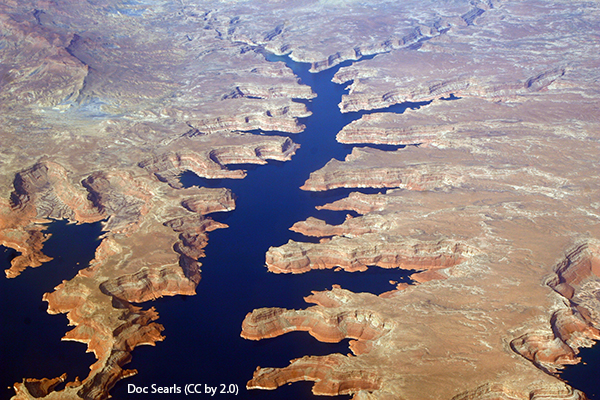
Doc Searls (CC by 2.0)
2. Find a point above the cove on the green colored layer with the rock unit label Jm. Imagine you are walking to the lake on the map from the place where you see the Jm label. Which other rock unit layers would you pass? Can you tell which is the oldest layer and which is the youngest layer? Explain your reasoning.
3. Use the “Correlation of Selected Geologic Units” to find the ages of the rock layers you passed through.
4. Go to the online map. On the second page “Plate 2” of the online map, read the detailed “Description of Geologic Units” to find out about Jm and the neighboring units. Make a hypothesis about how these rocks formed. Research about the geologic history of this period in North America.
5. If the lake level dropped, what do you think the map would look like? (For a clue, look along the shoreline at the southeast corner of the Smoky Mountain Quadrangle map where there are additional layers exposed at the surface.) Are the additional layers younger or older than those at the edge of the lake? Explain.
6. Use the “Correlation of Selected Geologic Units” to find the ages of the rocks that would be exposed if the water level dropped. Find out about the past environment.
Download a printer-friendly PDF of the 2021 Geologic Map Day activities, map and key here
NGSS Connections for Activities
Disciplinary Core Ideas
• Earth’s systems: 1, 2, 3, 4
• Earth and human activity: 1, 2, 3, 4
Crosscutting Concepts
• Patterns: 1, 2, 3, 4
• Structure and function: 1
• Scale, proportion, quantity: 2
• Cause and effect: 3
• Stability and change: 4
Science and Engineering Practices
• Planning and carrying out investigations: 1
• Analyzing and interpreting data: 1
• Developing and using models: 2, 3, 4
• Obtaining, evaluating, and communicating information: 2
• Engaging in argument from evidence: 3
• Asking questions and defining problems: 4