Earth Science Week Classroom Activities
How Dangerous Are Tsunamis?
Activity Source:
Adapted with permission by Geological Society of America.
Imagine playing beside the ocean, when suddenly, the water drops. Where the water used to be, there are wriggling fish and ribbons of seaweed. What do you do?
You could be seeing the first sign of a tsunami ─ a long wave formed in the ocean when the sea floor moves suddenly. Most tsunamis happen because of large earthquakes on the ocean floor. Others form because of landslides, volcanoes, or even meteors hitting the ocean. The cause of a tsunami can be far away, on the other side of the ocean. Many tsunamis are small, but they also can be large, up to 10 feet high or more. When water rises that much, it moves quickly and powerfully. Tsunamis are natural, but when they reach people, they can become disasters.
Because the Pacific Ocean has a lot of the kind of earthquakes that move the ocean floor, Alaska, Hawaii, and the west coast of the United States plan for tsunamis. Some faults are far away from the shore, but there is one just off the coast of Oregon and Washington. Tsunamis can also occur in the Atlantic and Caribbean.
In the United States, the National Oceanic and Atmospheric Administration (NOAA) uses information about earthquakes to predict where tsunami waves will travel and when the waves will arrive. You can use NOAA’s information to think about how a tsunami could affect you.
Questions to consider:
- What could you do if a tsunami was predicted to arrive in less than an hour?
- What could you do if a tsunami was predicted to arrive in eight hours?
- Look at a map of one of the following cities: Bellingham, Washington; Crescent City, California; or Hilo, Hawaii. If a tsunami was expected, where would you go? How would you get there?
Materials
- Access to internet for complete activity information and worksheets
Procedure
1. Link to Explore Tsunami for Teacher Notes and Student Exercises (a free partial download from GSA’s ETeach Resources).
2. Time and Tide: Practice plotting tide data from Australia to figure out when a tsunami struck and how destructive it may have been.
3. Hawaii Wave: Analyze a tsunami travel time chart to predict when a tsunami triggered near Hawaii will reach other Pacific Rim cities.
4. See Explore Tsunami, one of a series of 16 classroom resources on a range of geoscience topics, available at minimal cost from GSA.
Additional Tsunami Resources Online
-
Tide predictions and water level measurements for NOAA stations.
-
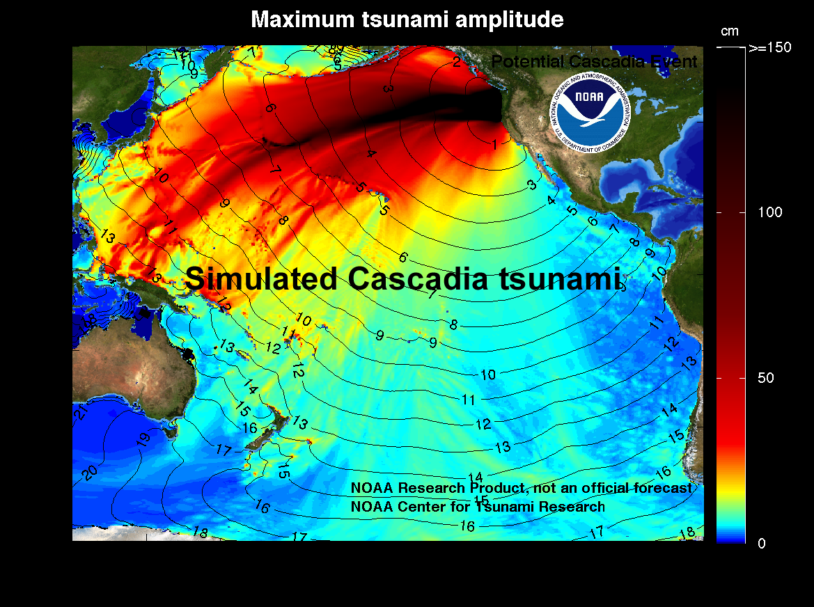
Predicted water height and travel time for a tsunami from the Cascadia subduction zone (Oregon and Washington).
NGSS 3-D Learning
- Science and Engineering Practices ─ Analyzing and Interpreting Data
- Disciplinary Core Ideas ─ Earth and Human Activity
- Crosscutting Concepts ─ Patterns