Earth Science Week Classroom Activities
Surface Processes
Activity Source:
Organizing partners of Geologic Map Day are the U.S. Geological Survey, the Association of American State Geologists, the National Park Service, the Geological Society of America, NASA, and the American Geosciences Institute.
Part A: Younger Deposits
Active erosion wears away surface rocks while deposition piles loose sediments on top of existing surfaces. Over time loose sediments may be compacted and cemented, which forms sedimentary rocks. Younger rocks and sediments are also shown on the geologic map. Let’s look for evidence of young rocks and active deposition using the map and other tools.
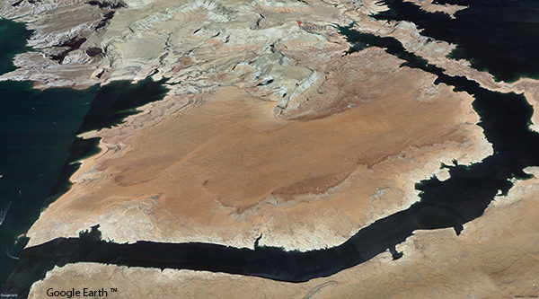
Google Earth™
- In Google Earth™ go to Alstrom Point. Set the view to the north and to 3D. Zoom into the large area called The Sand Hills, which is south of Alstrom Point (shown in above image).
- Explore the area from different angles. Look for shapes and patterns on the surface. Look for clues around the edges of the layer and how it rests on the layer below.
- Find the same layer on the geologic map. Write down the two- or three-letter rock unit label for this layer.
- Return to Google Earth™ and look for a layer to the north of Alstrom Point that appears to be similar.
- Confirm that the layer is similar using the rock unit labels. How far is this similar layer from the lake?
- Use the “Description of Geologic Units” on the online map (on “Plate 2” at https://bit.ly/21xGMD2) to find information about the layer. Compare this to your ideas about how the layer formed.
- In Google Earth™, zoom out so you can see the northern part of Arizona. Can you find the same layer? How does this observation change your ideas about how the layer formed?
Part B: Landslides
Over long periods of time, weathering breaks down rocks into sediments. Through the process of erosion, those sediments are transported by air, water, ice, and gravity.
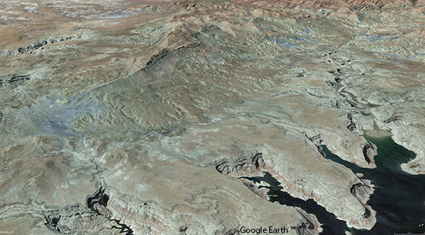
Google Earth™
- On the geologic map, go to the northern area of Last Chance Bay and look to the west. Examine the large deposit labeled Qms near the shore.
- On Google Earth™ find the same area (shown in above image). Print this view. Trace the edge of the Qms deposit shown on the geologic map (available here) onto your printed image.
- On Google Earth™ make observations of the highest and lowest parts of the deposit. (Hint: The elevation of the point under the cursor is shown in the lower right.)
- Move to the south end of the landslide where the rocks appear to be a lilac color (look on the lower right of the Google Earth™ image and move so the “Camera” position is about 37o0’40”N and 111o19’50”W). Zoom in and out to make observations of the surface. What evidence can you find that the landslide is being eroded?
- On Google Earth™ find the creek flowing into the northwest canyon of Last Chance Bay. Describe the deposit at the mouth of the creek. How do you think it formed?
- Find this same deposit on the geologic map. Record its label. Use the “Correlation of Selected Geologic Units” to find the age of the deposit. Relate the age to your claim.
- On the geologic map, follow the creek upstream. Also find it in Google Earth™. Find other deposits labeled Qms near the creek. How might the deposit at the mouth of the creek relate to mass wasting?
Download a printer-friendly PDF of the 2021 Geologic Map Day activities, map and key here
NGSS Connections for Activities
Disciplinary Core Ideas
• Earth’s systems: 1, 2, 3, 4
• Earth and human activity: 1, 2, 3, 4
Crosscutting Concepts
• Patterns: 1, 2, 3, 4
• Structure and function: 1
• Scale, proportion, quantity: 2
• Cause and effect: 3
• Stability and change: 4
Science and Engineering Practices
• Planning and carrying out investigations: 1
• Analyzing and interpreting data: 1
• Developing and using models: 2, 3, 4
• Obtaining, evaluating, and communicating information: 2
• Engaging in argument from evidence: 3
• Asking questions and defining problems: 4