Earth Science Week Classroom Activities
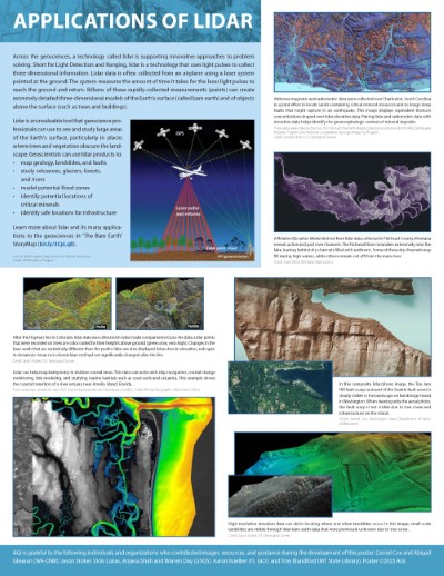
Applications of Lidar
Look at the Applications of Lidar side of the GMD poster
click here to see a larger version
-
Learn more about the United Nation’s Sustainable Development Goals (SDGs). For each image on the poster, list which SDGs could be aligned to what is shown and explain how.
-
Lidar can make geologic features apparent, such as fault scarps and landslides, that may not be visible insatellite imagery. What other types of geologic features or processes might be hidden that lidar can help locate and measure?
-
The USGS used lidar data to help make comparisons of pre- and post-fire conditions. What differences do you notice between the two models? What questions can be answered with these images? What other questions do you have after analyzing these models?
-
Three images on the poster show rivers. List how these rivers are similar and how they are different. What could be some factors causing these differences?
-
Consider the Montana active and past river channels in the purple image on the right side of the poster. What do you notice about the right side of the image and the left side? What might have caused these differences?
-
Examine the top right image that displays the airborne magnetic and radiometric data collected over Charleston, South Carolina. What do you notice about the bright yellow colors that display a concentrated thorium deposit? Is there a pattern that you see? Are there common locations where they are found? What might explain your observations? Learn more about this image by watching the ESW webinar, The Future of Earth’s Critical Materials, on October 12 during ESW.
NGSS
PE: Engineering, Technology, and Applications of Science, 2-ESS1-1, 4-ESS2-2, MS- ESS2-2, HS- ESS2-1
DCI: The History of Planet Earth; Earth’s Materials and Systems; Plate Tectonics and Large-Scale System Interactions
SEP: Analyzing and Interpreting Data; Constructing Explanations and Designing Solutions; Developing and Using Models
CCC: Patterns; Scale Proportion and Quantity; Stability and Change