Earth Science Week Classroom Activities
Critical Zone

Activity Source:
The Critical Zone (CZ) is defined as the zone at Earth’s land surface extending from the top of the vegetation canopy through soil to subsurface depths at which fresh groundwater freely circulates. This is the zone where most terrestrial life — including humanity — resides.
The U.S. Critical Zone Observatories (CZOs) provide important platforms for studying processes occurring in this zone. The CZOs aim to advance interdisciplinary studies of Earth surface processes, partly to recognize and predict variations in processes resulting from humans’ land use and climate change. You can learn more at criticalzone.org.
The eight CZOs work together. One cross-site activity is a Light Detection and Ranging (LiDAR) dataset. The light equivalent of sonar, LiDAR can provide high-resolution, three-dimensional images of Earth’s surface. For example, LiDAR data can reveal micro-topography that is difficult for a field scientist to recognize and is not represented well on topographic maps. For more information, see the LiDAR handout in the Earth Science Week 2013 Toolkit or go to http://oceanservice.noaa.gov/facts/lidar.html.
Materials
- Computer with Internet access
- Paper and pen or pencil
Procedure
-
Use Google Maps to find Pine Grove Mills, Pennsylvania. Follow State Route 26 south from Pine Grove Mills to the intersection with Harry’s Valley Road. Your study area lies to the northeast (right on the map) between this intersection and Beaver Pond. Study and jot down notes about the topography and landscape here.
-
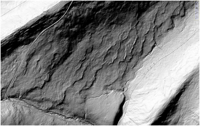
View the image below, a LiDAR image of your study area, noting that it is about two miles long by one mile wide. Do you see anything unusual in the landscape, anything that you did not recognize on the Google Maps imagery?

Courtesy of Critical Zone Observatories
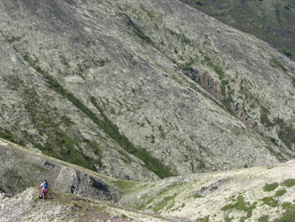
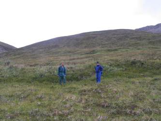
- View the images below, taken from the Chugach and Talkeetna Mountains in Alaska, respectively. Do you see anything in these photos that helps you better understand the landscape in your Pennsylvania study area?
Courtesy of Critical Zone Observatories
Courtesy of Critical Zone Observatories
-
Go to the Pennsylvania Bureau of Topographic and Geologic Survey web site and download Educational Series 6, Pennsylvania and the Ice Age (http://www.dcnr.state.pa.us/topogeo/publications/pgspub/educational/index.htm). Focus on the centerfold map entitled “Glacial Deposits of Pennsylvania.” Was your study area once covered by glacial ice?
-
Read the section entitled “Periglacial Phenomena” on page 25 of the report. Can this information help you understand your study area? Consider the relationship between Alaska today and Pennsylvania in the past. How might the Alaskan photos be relevant to considering present-day Pennsylvania?


