Earth Science Week Classroom Activities
Lidar Improves Geologic Maps
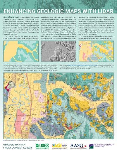
Look at “Enhancing Geologic Maps with Lidar” side of the 2023 GMD poster.
click here to see a larger version
-
Examine the top three images on the poster. Make comparisons between the outdated geologic map on the left and the updated geologic map on the right. How has the map improved? Point out specific places where it has changed.
-
Examine the lidar map in the middle. How does this image differ from the geologic maps? How do you think the lidar data helped improve the geologic map?
-
Examine the detailed geologic map on the bottom of the poster. Can you find a steep incline? A body of water? A fault? What rock type is most common? What features of the map require the use of a key to be understood?
-
Notice the thin black line running diagonally across the large geologic map. Infer what the cross section through this line might look like. Draw your predictions, then examine and make comparisons to the published cross section found at NGMDB Product Description Page
NGSS
PE: 4-ESS2-2,MS- ESS2-3
DCI:The History of Planet Earth; Plate Tectonics and Large-Scale System Interactions
SEP: Analyzing and Interpreting Data
CCC: Patterns