Earth Science Week Classroom Activities
Looking Below Earth’s Surface
Activity Source:
Organizing partners of Geologic Map Day are the U.S. Geological Survey, the Association of American State Geologists, the National Park Service, the Geological Society of America, NASA, and the American Geosciences Institute.
The Utah Geologic Survey’s interactive “Geologic Map Portal”) allows you to see the geologic map on top of a 3-dimensional surface and topographic map. This is helpful for visualizing how the geology shown on the map appears in nature (image below). Geologists also make representations of what a slice through the Earth would look like, called a cross section. A cross section shows rock layers and the structures that contain them below the surface.
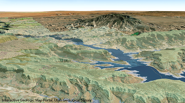
Interactive Geologic Map Portal, Utah Geological Survey
- Practice using the interactive map portal to explore the geologic map. Zoom to Lake Powell. Roll your cursor over the controls in the gray bars on the right and on the left to see what each does. Use the “Go to a location” button on the right side to locate Gunsight Bay. Use the controls on the left to zoom in. Use the “Tilt view” button on the left to tilt the viewer to get a good 3D effect (you will need to be zoomed in so the “scale” reading at the bottom center of the map is about 1:40,000). Move from Gunsight Bay eastward to Last Chance Bay.
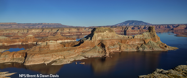
NPS/Brent & Dawn Davis
- Examine the geology of Gunsight Butte shown (in photo to the right). Try to identify the different rock layers. Record the number of layers you identified. Describe the orientation of these layers.
- Look at the geologic map. How does the orientation of the layers on the west side of Last Chance Bay compare to the east side of Last Chance Bay?
- Click on the “Tilt view” button until the view is straight down. Find the black line that runs diagonally across the northern part of Last Chance Bay. The ends of the line are labeled B at the southwest and B’ (pronounced “B prime”) at the northeast. Find this line on the geologic map on the poster front. This line shows the location of the cross section. Examine the cross section shown on the front of the poster below the geologic map. How does the orientation of the layers compare to your ideas about the relationships among layers around Last Chance Bay?
- Find Rock Creek on the map and the cross section. (Hint: Rock Creek flows southward into Rock Creek Bay.) Based on what you can observe on the map, what do you think is the impact of the creek on the landscape?
- Find the words “anticline” and “syncline” on the cross section. Look up what they mean. How do they form?
- If another cross section were oriented northwest-southeast cutting through Last Chance Bay (that is, perpendicular to the B-B’ cross section), how would its layers compare to the original B-B’ cross section?
Download a printer-friendly PDF of the 2021 Geologic Map Day activities, map and key here
NGSS Connections for Activities
Disciplinary Core Ideas
• Earth’s systems: 1, 2, 3, 4
• Earth and human activity: 1, 2, 3, 4
Crosscutting Concepts
• Patterns: 1, 2, 3, 4
• Structure and function: 1
• Scale, proportion, quantity: 2
• Cause and effect: 3
• Stability and change: 4
Science and Engineering Practices
• Planning and carrying out investigations: 1
• Analyzing and interpreting data: 1
• Developing and using models: 2, 3, 4
• Obtaining, evaluating, and communicating information: 2
• Engaging in argument from evidence: 3
• Asking questions and defining problems: 4