Earth Science Week Classroom Activities
Third From the Sun
Activity Source:
“Third From the Sun” from the University of California at Berkeley, 2001. Adapted with permission.
Background
Since our beginnings, we humans have had a narrow view of our home - Earth. For many years, standing on the ground and looking around or climbing a mountain and squinting down were the most useful ways people had of trying to understand the planet’s surface. Only in the past few hundred years have we been able to better understand what the planet really looks like. We no longer needed to rely on a mountain to climb to take a look around. From hot air balloons to airplanes, and finally with satellites in outer space, we take pictures from above that help us better understand the Earth.
In 1972, NASA launched a special satellite called Landsat that contained a new camera designed to take pictures of the Earth. Why was this satellite so incredible? Well, it could take a series of pictures of almost the entire Earth over and over again, season after season, month after month, year after year. You will be seeing Landsat images in this activity.
Landsat
- Takes clear pictures of Earth from 570 miles out in space.
- Follows instructions from computers on Earth.
- Works in the extremely cold temperatures of space and last for many years.
- Orbits the Earth at about 570 miles out in space. This is roughly equal to the distance from San Francisco to San Diego, Boston to Pittsburgh, or Houston to Memphis.
- Takes pictures only in the day time. That makes sense, since using a flash camera from 570 miles away just won’t work!
- Captures images, each of which equals 13,000 square miles. That is an area about 115 miles long by 115 miles wide.
- Looks at smaller areas of the Earth also. How’s this for small? It can focus on an area of 210 square feet, which is about 14.5 feet by 14.5 feet. You could mark this off yourself - seven very long kid steps equals about 14 feet.
- Completes a full orbit around the earth every 103 minutes.
- Takes 16 days to take its pictures of the entire Earth. Then it begins taking pictures all over again.
Materials
- Internet-connected computer
- Map or globe
Procedure
- Read about the history of Remote Sensing.
- Make observations of the images of geographical features below to guess what the satellite pictures are showing:
Image A:
Credit: University of California at Berkeley, 2001
- What do you see in this picture? Why do you think that?
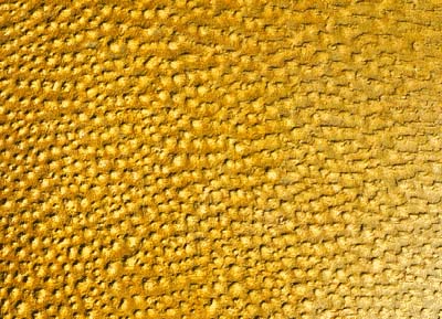
Click here to reveal suggestions
- Palm Trees
- Boulders
- Sand dunes
Image B:
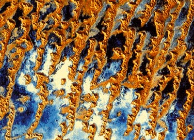
Credit: University of California at Berkeley, 2001
- What do you see in this picture? Why do you think that?
Click here to reveal suggestions
- Icy coastal islands
- Mountain tops
- A desert depression
Image C:
Credit: University of California at Berkeley, 2001
- What do you see in this picture? Why do you think that?
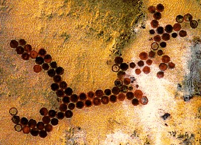
Click here to reveal suggestions
- Oil Tanks
- Irrigation fields
- Sink holes
- Browse through a list of 50 satellites that do remote sensing.
- Choose 3 satellites to compare and contrast. Research:
- what types of sensors each satellite has.
- what types of images and/or data each satellite takes.
- unique capabilities or facts about each satllite.
- who might use the images or data that come from each satellite.
Click here to reveal the answers for the satellite images above
Image A: sand dunes
Image B: a desert depression
Image C: irrigation fields